Sunday, September 23, 2012

Mt. Monadnock via trails less traveled

Saturday, 8/25/12: One of the advantages of taking less-traveled trails on Monadnock is that you avoid the hordes of hikers on the mountain. On some trails (Surprise Point and Cliff Walk), we didn't see a soul.

I am now a convert to electrolyte drinks when it's hot or humid. I drank the equivalent of 3 32-oz. bottles Zero Powerade and I felt great at day's end -- in contrast to how depleted ("wilted") I normally feel after only drinking water.

Wildlife sighting -- what I believe is a garter snake.

This was good training for the Lafayette Ridge hike we plan later this year!

5.8 miles RT, 2,277' elevation gain (approx. 6 hours with stops)
Summit: Mt. Monadnock (3,165')
Route: White Dot, Cascade Link, Spellman, Pumpelly to the summit; White Arrow, Surprise Point, Cliff Walk and Lost Farm Trails on the descent

Snake
Snake on trial to Mt. Monadnock

Friday, September 21, 2012

Wapack Trail: Watatic Mountain and Binney Pond


8/18/12 - On my first hike following my hamstring injury, we chose a portion of the Wapack Trail, starting from Route 119 in Ashburnham. We ascended Watatic Mountain, then headed north to Nutting Hill. At Emerson Hill, due to logging in the area, we were re-routed. The 1.75-mile detour had us walking up Emerson Hill Road and then up Binney Hill Road before reconnecting with the Wapack.

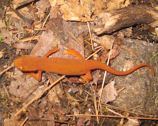
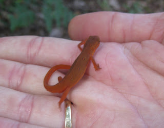
Our top two nature sightings were a red eft and a dragonfly apparently eating a damsel fly.


We found two geocaches in the area, the last one at our lunch spot overlooking Binney Pond. (Note to selves: geocaching destroys your average mph :-) )

Using an electrolyte drink instead of water appears to help me handle high heat and humidity, though I did wilt at the end in the direct sun. 

It feels great to be hiking again!

11 miles RT, ~1,200' elevation gain
Summit: Watatic Mountain (1,832')
Route: Wapack Trail from Route 119 (including a 1.75 mile detour south of Binney Pond); return on Wapack and State Trails.
Dragonfly vs. damselfly
Dragonfly vs. damselfly, Wapack Trail
Red eft
Red Eft on Wapack Trail near Watatic Mountain
Red Eft
Red Eft in Hand

Rocky Mountain High

June 2012 - The top five highlights of our vacation to the Rocky Mountain National Park and the mile-high cities of Boulder and Silverthorne in Colorado:

 - up close and personal with a wild bull elk
 - Nancy's beautiful wedding
 - dog-sitting Charlie and Sally
 - the Bear Lakes Wilderness Area hike, including the three lakes -- Nymph, Dream and Emerald (10,080') -- in Rocky Mountain National Park
 - the porcupine on our Boulder Lake (9,782') hike in the Eagles Nest Wilderness Area (near Silverthorne)
Elk in Rocky Mountain National Park
Vicki and young bull elk in Rocky Mountain National Park
View in Bear Lakes Wilderness Area
View between Dream and Emerald Lakes in RMNP

Wednesday, January 4, 2012

Icy ledges on Peaked Mountain (North Conway, NH)

12/30/11 - The wind was quite nippy on the icy ledges of Peaked Mountain and we had a few snow flurries. The upper part of Peaked Mountain Trail passes through interesting stands of red and pitch pine. Looking north, we watched snowmaking and and skiers schussing down Cranmore's trails.

Snowy weather conditions prevented us from seeing either Mt. Washington or Mt. Chocorua. But it was delightful nonetheless. Thanks goodness for micro-spikes on all of those icy ledges!

4.2 miles, 1,200'elevation gain (~4 hours RT)
Summit: Peaked Mountain (1,739')
Route: Peaked Mountain Trail

Easy winter hike on Sawyer River Road

12/29/11 - First John and I enjoyed the river views and sounds, taking many photos of river ice. Then we scrambled (I slid) to ascend the steep bank to the road.

We walked down Sawyer River Road until we reached the intersection with the Signal Ridge Trail, which leads to the summit of Mt. Carrigain. We had a lovely leisurely lunch (including orange milanos and chili mango!) overlooking the river.

~3 miles, virtually no elevation gain (~3 hours RT)
Summit: none
Route: along Sawyer River, then along Sawyer River Road (unplowed)

My first night hike - Cathedral Ledge (NH)

At night, this moderate climb up an unplowed road to a clifftop provides nice views eastward of Cranmore Mountain's lighted ski trails.

On the ledges, even with headlamps, it was a bit tricky finding the road back down, but when we did, it was a quick and easy descent to the base of Cathedral Ledge and the car.

Benefits? My first night hike and a clear view of Jupiter with John!

2.8 miles, 650'elevation gain (~40 minutes up
Summit: Cathedral Ledge (1,150')
Route: Cathedral Ledge Auto Road (unplowed)